Trip Duration
11 Days
Trip Grade
Moderate
Transportation
Flight to Lukla and lukla to Kathmandu
Max. Altitude
5,357 m
Departure From
Kathmandu to Kathmandu
Destination
Everest Region
Meals
Breakfast, Lunch, Dinner
Accomodation
Tea house
Season
Spring (Mar-May) & Autumn (Sep-Nov)
Trip overview
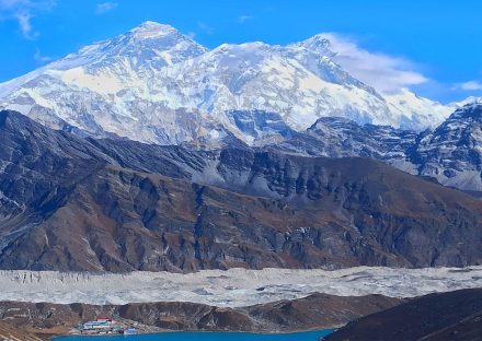
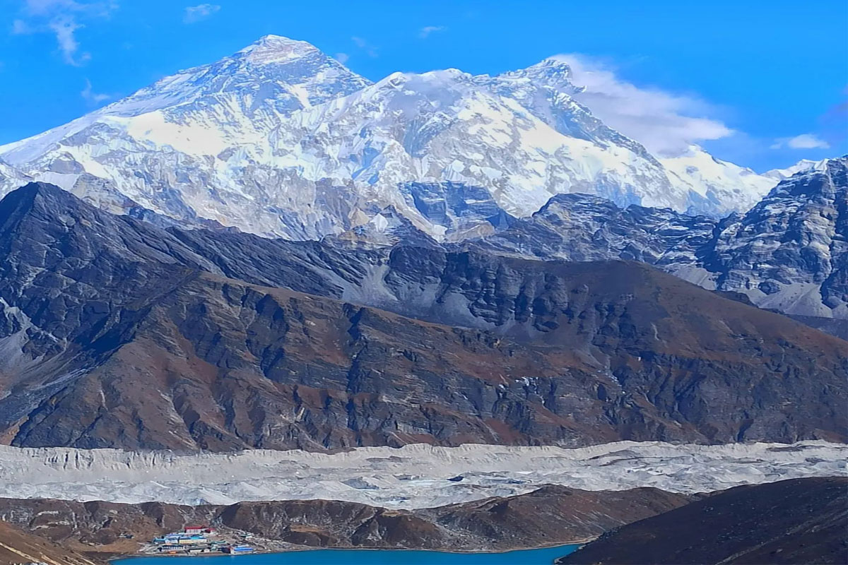
Gokyo Ri Hike
The Gokyo Ri Hike is one of the most rewarding trekking experiences in Nepal. Nestled in the Everest region, this trail offers breathtaking views of the world’s highest peaks, glacial lakes, and vast valleys. Unlike the busier Everest Base Camp hike, the Gokyo Ri Hike provides a quieter, more peaceful alternative with equally stunning scenery.This trek is famous for its stunning high mountain views and pristine lakes. which is why it is also known as the Gokyo Lake Trek.
Why Choose the Gokyo Ri Hike?
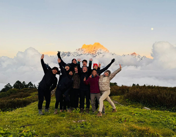
The Gokyo Ri Hike is perfect for trekkers seeking adventure, solitude, and panoramic views of the Himalayas. This trek is known for its incredible vantage point at Gokyo Ri (5,357m), from where you can see four of the world’s 8,000-meter peaks: Everest, Lhotse, Makalu, and Cho Oyu. Additionally, the hike takes you to the pristine Gokyo Lakes, a series of turquoise glacial lakes that enhance the beauty of the journey.
Unlike the crowded trails leading to Everest Base Camp, the trek follows a quieter path. The journey takes you through remote Sherpa villages, high mountain passes, and stunning landscapes, providing an authentic Himalayan experience.
Best Time for the Hike
The ideal seasons for the Gokyo Ri Hike are spring (March to May) and autumn (September to November). These months offer clear skies, moderate temperatures, and the best visibility for mountain views. Winter trekking is possible but presents challenges due to heavy snowfall and freezing temperatures. Monsoon season (June to August) brings rain, making the trails slippery and risky.
Gokyo Ri Hike Route Overview
Lukla to Namche Bazaar (3,440m)
The journey begins with a scenic flight from Kathmandu to Lukla (2,860m). From Lukla, the trek proceeds to Phakding (2,610m) before reaching Namche Bazaar, the vibrant Sherpa town and the gateway to Everest. Trekkers typically spend a day acclimatizing here before ascending higher.
Namche Bazaar to Dole (4,200m)
Leaving Namche, the route diverges from the classic Everest Base Camp trail and heads towards Dole. This section introduces trekkers to stunning rhododendron forests, waterfalls, and magnificent mountain views.
Dole to Machhermo (4,470m)
The trail gradually ascends to Machhermo, a small settlement with breathtaking views of Cho Oyu. This part of the Gokyo Ri Hike is crucial for acclimatization as altitude gain becomes more significant.
Machhermo to Gokyo (4,790m)
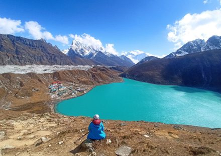
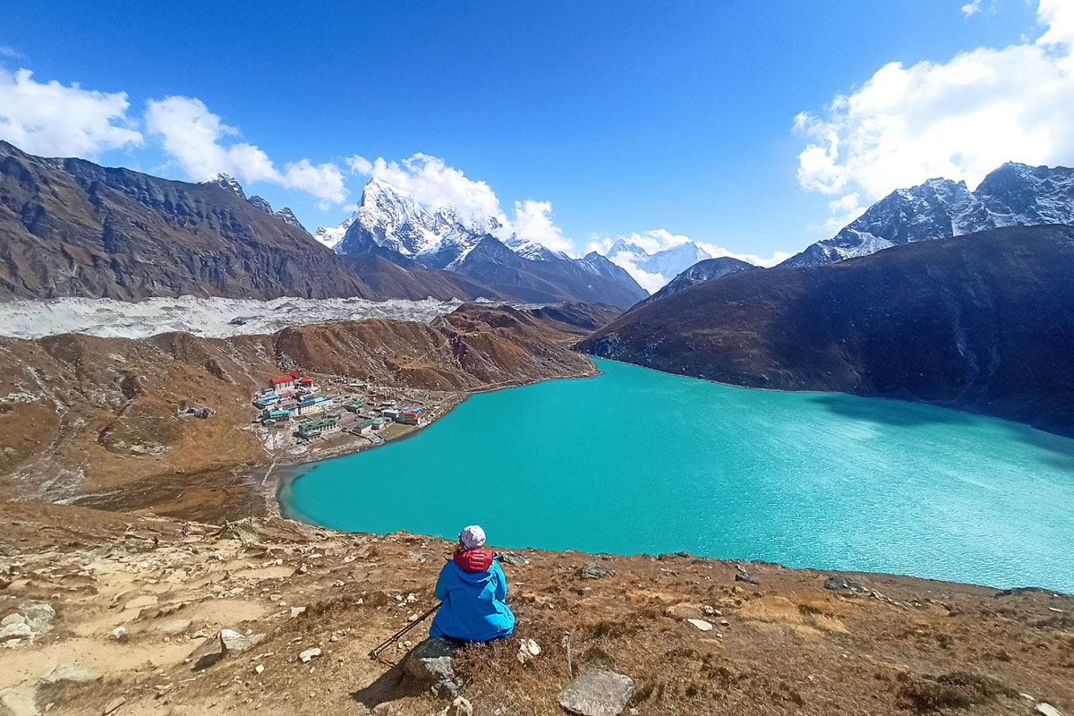
The path from Machhermo to Gokyo is one of the most scenic segments, leading trekkers past the Gokyo Lakes. The third lake, Dudh Pokhari, sits beside the Gokyo village, offering an unparalleled alpine setting.
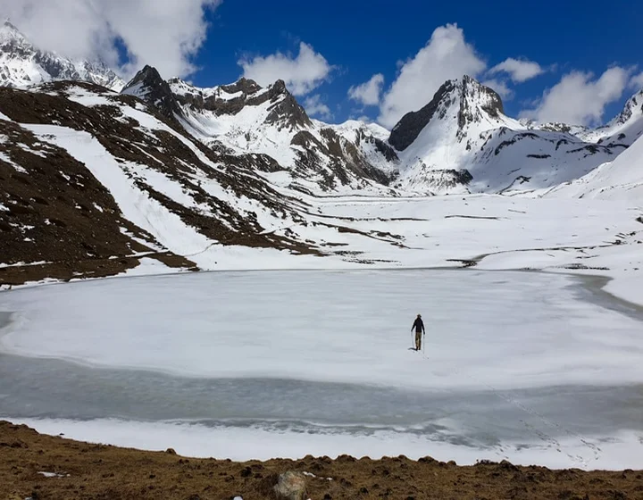
Gokyo to Gokyo Ri (5,357m) and Back
Summiting Gokyo Ri is the highlight of the hike. Trekkers typically start early in the morning to witness the sunrise over the Everest region. From the summit, the panoramic views of Everest, Lhotse, Makalu, and Cho Oyu create an unforgettable spectacle.
Return Journey
After exploring Gokyo, trekkers retrace their steps back to Namche Bazaar and Lukla before flying to Kathmandu.
Challenges of the Gokyo Ri Hike
While the Gokyo Ri Hike is less strenuous than the Everest Base Camp trek, it still presents challenges, including:
- High Altitude: The trek ascends above 5,000m, making altitude sickness a potential risk.
- Cold Temperatures: Nights can be extremely cold, especially in the higher elevations.
- Physical Endurance: The trek requires good fitness, as daily hikes range between 5 to 7 hours on rugged terrain.
Essential Tips for the Hike
- Acclimatize Properly: Spend at least two nights in Namche Bazaar to adjust to the altitude.
- Pack Wisely: Bring warm clothing, sturdy hiking boots, and essential gear like trekking poles and a good sleeping bag.
- Stay Hydrated: Drink plenty of water to prevent altitude sickness.
- Hire a Guide or Porter: Although the trail is well-marked, hiring a guide enhances safety and navigation.
- Respect Local Culture: The Everest region is home to the Sherpa community, and respecting their customs and environment is essential.
Gokyo Ri Hike vs. Everest Base Camp Trek
The Gokyo Ri Hike and the Everest Base Camp (EBC) hike both offer breathtaking experiences in the Everest region, but they differ in several key aspects. Gokyo Ri, standing at 5,357m, offers a less crowded alternative to the EBC hike, which reaches an altitude of 5,364m. While EBC is known for its close-up views of Everest and the dramatic Khumbu Icefall, Gokyo Ri provides stunning panoramic views of Everest along with the pristine Gokyo Lakes. In terms of difficulty, both treks are challenging, though EBC is often considered slightly tougher due to its popularity and higher foot traffic. If you seek solitude and mesmerizing lake landscapes, Gokyo Ri is ideal, whereas EBC delivers the ultimate classic Everest trekking experience.
By adding just 3–4 extra days, you can combine the Gokyo Ri Trek and Everest Base Camp Trek into one epic adventure. Known as the Cho La Pass Trek, this route takes you over the high-altitude Cho La Pass (5,420m), seamlessly connecting the stunning Gokyo Valley with the iconic Everest Base Camp trail.
Benefits of Booking with Nepal Wilderness Team:
- Enjoy Expert Guidance – Trek with experienced local guides who know the terrain, culture, and best routes.
- Experience Authentic Nepalese Hospitality – Stay in handpicked teahouses and lodges run by local families.
- Trek at Your Own Pace – Get personalized itineraries and flexible schedules to match your fitness level.
- Ensure Safety and Comfort – Travel with a well-equipped team that prioritizes acclimatization and safety measures.
- Support Local Communities – Contribute directly to the livelihood of local guides and porters by choosing a responsible trekking company.
Conclusion
The Gokyo Ri Hike is an exceptional alternative to the Everest Base Camp trek, offering breathtaking mountain views, serene glacial lakes, and a peaceful trekking experience. With proper preparation and acclimatization, this journey rewards trekkers with an unforgettable adventure in the Himalayas. Whether you’re an experienced trekker or a first-time visitor to Nepal. The Gokyo lake trek provides a remarkable journey through breathtaking landscapes, diverse cultures, and unforgettable high-altitude adventures.
Note : Flights to Lukla typically operate from Ramechhap during the peak trekking seasons, which run from April to May and October to November.
Itinerary
Flight from Kathmandu to Lukla:
Distance: 140 kilometers (approximately 87 miles).
Time: 35 minutes.
The day starts with a morning flight from Kathmandu (1,400 meters / 4,593 feet) to Lukla (2,850 meters / 9,350 feet). This is an exhilarating flight, offering spectacular views of the Himalayas as you fly over valleys and ridges. The airstrip in Lukla is known for being one of the most scenic and adventurous airports in the world, perched high on a mountain, surrounded by towering peaks.
Trek from Lukla to Phakding:
Distance: Approximately 8 kilometers (5 miles).
Time: 3 hours of walking.
Upon arrival in Lukla, you'll begin the trek to Phakding (2,650 meters / 8,562 feet), which takes around 3 hours.
The trail initially descends slightly as you walk through the vibrant village of Lukla, passing small lodges and tea houses. You'll then enter a forested path that leads to the banks of the Dudh Koshi River.
Along the way, you'll cross several suspension bridges and pass by Sherpa villages. The path is relatively gentle, with gradual ups and downs as you walk alongside the river. The surrounding landscape offers beautiful views of the forested hills and snow-capped peaks, making for a pleasant introduction to the trek.
You will arrive at Phakding, a small village located on the riverbanks, where you'll stay overnight at a lodge. The village offers stunning views of the surrounding mountains and the chance to relax before continuing your journey deeper into the Khumbu region.
Distance: 10-12 kilometers (6-7 miles)
Walking Time: 6-7 hours
Elevation Gain: 790 meters (2,590 feet)
Trek Overview:
Start in Phakding: Begin with a gentle walk, crossing the Dudh Koshi River and passing through villages like Jorsale. The trail is mostly flat initially.
Steady Ascent: After Jorsale, the trail climbs steeply. The hike becomes more challenging, but offers views of the river and distant peaks.
First Views of Everest: As you near Namche, you’ll catch your first glimpse of Mount Everest.
Arrive at Namche Bazaar: After a long ascent, you'll reach Namche Bazaar (3,440m), a vibrant town with stunning mountain views. This is where you'll stay overnight, allowing time for acclimatization.
Namche Bazaar (3,440m) is the perfect place to rest and acclimatize before heading to higher altitudes. This day helps your body adjust to the lower oxygen levels, reducing the risk of altitude sickness.
Exploring Namche Bazaar
Hike to Syangboche (3,780m) or Hotel Everest View for breathtaking views of Everest, Ama Dablam, and Lhotse.
Visit the Sherpa Museum to learn about local culture and mountaineering history.
Stroll through the lively market, where you can explore local goods, bakeries, and shops.
Why Acclimatization is Important
Spending this extra day at Namche allows your body to gradually adapt to the altitude, ensuring a safer and more enjoyable trek ahead.
Distance: Approximately 11 km (7 miles)
Walking Time: 5-6 hours
Elevation Gain: 760 meters (2,485 feet)
Trek Overview:
Leaving Namche Bazaar: The trail starts with a gradual ascent above Namche, offering beautiful views of Ama Dablam, Everest, Lhotse, and Thamserku.
Split at Sanasa: After about an hour, you'll reach Sanasa, where the path to Gokyo Valley splits from the main Everest Base Camp route. Taking the left trail, you ascend through rhododendron and pine forests.
Steep Ascent to Mong La (3,975m): A steep climb brings you to the ridge of Mong La, a small settlement with stunning mountain views. This is a great spot for a short rest.
Descent to Phortse Tenga (3,680m): After Mong La, the trail descends through forests to Phortse Tenga, a small village by the Dudh Koshi River.
Final Climb to Dole: From Phortse Tenga, a steady uphill climb leads to Dole (4,200m). As you ascend, the vegetation starts to thin, and the landscape becomes more rugged, with yak pastures and snow-capped peaks in the distance.
Arrival at Dole
Dole is a small settlement with basic lodges, surrounded by stunning mountain views. The air is noticeably thinner here, making it a great place to rest and acclimatize before continuing toward Gokyo.
Distance: Approximately 5 km (3 miles)
Walking Time: 4-5 hours
Elevation Gain: 270 meters (885 feet)
Trek Overview:
Gradual Ascent from Dole: The trail begins with a steady climb through open landscapes, passing yak pastures and small summer settlements. The vegetation becomes sparse as you gain altitude.
Scenic Mountain Views: Along the way, you'll enjoy stunning views of Cho Oyu (8,188m), Thamserku, Kangtega, and other peaks.
Passing Through Lhabarma and Luza: You’ll pass small settlements like Lhabarma (4,330m) and Luza (4,370m), where you might see yaks grazing.
Final Stretch to Machhermo: The last section is a gradual ascent to Machhermo (4,470m), a small village in a valley with breathtaking views.
Arrival at Machhermo
Machhermo is known for being the site of an alleged Yeti sighting in 1974, adding a touch of mystery to the trek. The village has a few lodges and is an important acclimatization stop before heading to Gokyo.
Distance: Approximately 7 km (4.3 miles)
Walking Time: 4-5 hours
Elevation Gain: 320 meters (1,050 feet)
Trek Overview:
Steady Ascent from Machhermo: The trail climbs gradually along a ridge, offering incredible views of Kangtega, Thamserku, and Cho Oyu (8,188m), the sixth-highest mountain in the world.
Climbing Above the Dudh Koshi Valley: The trail follows the Dudh Koshi River, with a steep ascent leading to the first of the Gokyo Lakes.
Passing the First and Second Lakes: You will trek past a series of glacial lakes, the first being Longponga Tsho (4,690m) and the second Taujung Tsho (4,710m), both reflecting the surrounding peaks in their clear blue waters.
Arrival at Gokyo (4,790m): The final stretch brings you to Gokyo Village, located beside the stunning third lake, Dudh Pokhari. This peaceful settlement provides breathtaking views of the surrounding mountains and glaciers.
Rest and Acclimatization at Gokyo
After arriving, you can explore the lakeside and relax, preparing for the next day's climb to Gokyo Ri (5,357m) for one of the best panoramic views in the Everest region.
Gokyo Ri Elevation: 5,400m (17,814ft)
Ascent Time: 2-3 hours
Descent Time: 1.5-2 hours
Elevation Gain: 610m (2,000ft)
Early Morning Summit of Gokyo Ri
Start early before sunrise to reach the summit for breathtaking panoramic views.
The steep, challenging climb takes about 2-3 hours, but the effort is rewarded with one of the most stunning viewpoints in the Everest region.
From the top, you'll see Everest (8,848m), Lhotse (8,516m), Makalu (8,485m), Cho Oyu (8,188m), and the Ngozumpa Glacier, the longest glacier in the Himalayas.
After spending some time at the summit, descend back to Gokyo for breakfast.
Rest & Exploration Around Gokyo
Spend the day acclimatizing, relaxing, or taking a short hike to the Fifth Lake (Ngozumba Tsho, 4,980m) for another incredible Everest viewpoint.
Enjoy the serene atmosphere of the turquoise Gokyo Lakes, surrounded by snow-capped peaks.
This rest and acclimatization day helps prepare for the trek back and any potential further challenges ahead.
Distance: Approximately 13 km (8 miles)
Walking Time: 6-7 hours
Elevation Loss: 840 meters (2,625 feet)
Trek Overview:
Leaving Gokyo: The trek begins with a descent along the Dudh Koshi River, retracing part of the trail back towards Machhermo and Dole.
Steep Descent to Phortse Tenga: The trail gradually descends past Lhabarma and Luza, offering fantastic views of Cho Oyu and surrounding peaks.
Crossing to Phortse: Instead of continuing to Namche, you take a different route towards Phortse, a less crowded Sherpa village known for its stunning views and traditional houses.
Arrival at Phortse (3,950m): This peaceful village offers breathtaking views of Ama Dablam, Thamserku, and Kangtega, making it a perfect overnight stop.
This route provides a scenic alternative to the usual descent, allowing you to experience the beauty and culture of a quieter part of the Everest region.
Distance: Approximately 8 km (5 miles)
Walking Time: 5-6 hours
Elevation Loss: 510 meters (1,674 feet)
Trek Overview:
Leaving Phortse: The trail starts with a gradual descent before traversing along the mountainside with stunning views of Ama Dablam, Everest, and Thamserku.
Undulating Trail to Mong La: A series of ascents and descents lead to Mong La (3,975m), a scenic ridge offering panoramic mountain views.
Descent to Sanasa: After Mong La, the trail descends steeply to Sanasa, where it reconnects with the main Everest Base Camp route.
Final Stretch to Namche Bazaar: The last section involves a relatively easy walk back to Namche Bazaar (3,440m), where you can enjoy a hot meal, relax, and explore the vibrant town.
This is a rewarding day as you gradually return to lower altitudes, enjoying the final mountain views before heading back toward Lukla.
Distance: Approximately 18 km (11 miles)
Walking Time: 6-7 hours
Elevation Loss: 590 meters (1,935 feet)
Trek Overview:
Final Descent from Namche: The trek starts with a steep downhill section leading to the Hillary Suspension Bridge, crossing the Dudh Koshi River. This part of the trail can be tough on the knees, so trekking poles are helpful.
Passing Through Jorsale & Monjo: You’ll re-enter the Sagarmatha National Park, passing through forests and small villages like Jorsale and Monjo, where permits are checked.
Gentle Walk to Phakding: After Monjo, the trail becomes easier with gentle ups and downs, passing Phakding, where many trekkers spend their first night.
Last Stretch to Lukla: The final section involves a gradual uphill walk back to Lukla (2,850m), where you can celebrate the completion of the trek with your team.
Arrival in Lukla
Lukla marks the end of the adventure. You can relax, enjoy a warm meal, and reflect on the incredible journey before flying back to Kathmandu the next morning.
Flight Duration: 35 minutes
Elevation Loss: 1,450 meters (4,757 feet)
Journey Overview:
Early Morning Flight: Due to weather conditions in the mountains, flights from Lukla to Kathmandu typically operate in the morning. It's best to be prepared for potential delays due to unpredictable weather.
Scenic Flight: The short but thrilling flight offers breathtaking aerial views of the Himalayas, giving you one last glimpse of the stunning landscapes before landing in Kathmandu.
Arrival in Kathmandu: Once you land at Tribhuvan International Airport (TIA), you can either rest at your hotel or explore the city, celebrating the successful completion of your trek.
Included
- Domestic Flights: Kathmandu to Lukla and return.
- Meals: Italian, Chinese, Nepali, Indian, and European dishes (breakfast, lunch, dinner).
- Accommodation: Tea houses as per the itinerary.
- Kitbag and Sleeping Bag: For storing belongings and comfortable sleep at -25°C.
- Permits: Everest National Park and Khumbu Pasang Lhamu Rural Municipality permits.
- Guides and Porters: Licensed English-speaking guide and one porter per 2-3 participants.
- Staff Expenses: Meals, accommodation, salary, and insurance for guide and porter.
- Taxes: Necessary paperwork and all government/local taxes.
- Certificate: Appreciation certificate from Nepal Wilderness Trekking after successful completion.
Not Included
- International Flights: Airfare to/from Nepal.
- Visa Fees: Entry visa fees for Nepal (varies by duration).
- Kathmandu Accommodations: Meals and stays before and after the trek.
- Personal Gear: Equipment for high-altitude and cold temperatures.
- Emergency Rescue: Covered by your travel insurance.
- Beverages and Extras: Soft drinks, alcohol, bottled water, desserts, hot showers, and laundry.
- Tips / gratitude: For guide and porter.
- Other Expenses: Any costs not mentioned under "cost includes", and any delays or changes due to weather, illness, government policies, etc.
Join Us Upcoming Trips
Book this trip with us. Here are the upcoming dates. Feel free to share this trip with your friends and family. For custom trips or general inquiries contact us.
| Departure Date | Trip Duration | Price | Status |
|---|
Useful Info
- Above dates are guaranteed, but we can arrange private or solo trips on your preferred dates. Let us know your plans!
Essential Information for the Gokyo Ri Hike
1. Travel Insurance
Travel insurance is highly recommended for the Gokyo Ri Hike. It should cover high-altitude trekking (above 5,000m), emergency evacuations, medical expenses.
2. Accommodation Facilities
Accommodation along the Gokyo Ri trek consists of teahouses run by local families. These lodges provide basic yet comfortable rooms, typically with twin beds, blankets, and shared bathrooms. As you go higher, the facilities become more basic, so carrying a sleeping bag (we provide a -25 degree sleeping bag if you don't have your own) is advised for extra warmth.
3. Packing List, Gears, and Equipment
A well-prepared packing list is essential for a successful trek. Key items include:
- Clothing: Insulated jackets, thermal layers, moisture-wicking shirts, trekking pants, gloves, and a warm hat.
- Footwear: Sturdy trekking boots with good grip and woolen socks.
- Gear: Trekking poles, sunglasses, sunscreen, headlamp, and a sleeping bag (-10°C to -20°C).
- Backpack: A daypack (20-30L) for essentials and a larger backpack if carrying extra gear.
4. Guide and Safety Measures
Hiring a guide for the Gokyo Ri Hike enhances safety and navigation. Experienced guides provide route assistance, help with acclimatization, and share insights into local culture. Porters can also be hired to carry heavy loads. Safety measures include gradual acclimatization, staying hydrated, and recognizing altitude sickness symptoms.
5. Internet Services
Wi-Fi is available in most tea houses along the trail, but it becomes unreliable at higher altitudes. Alternatively, trekkers can purchase a local Ncell or Everest Link data package for better connectivity, though signals may be weak in remote areas.
6. Food on the Gokyo Ri Hike
Teahouses along the route serve a variety of meals, including traditional Nepalese dal bhat (rice, lentils, and vegetables), Tibetan bread, noodles, soups, momos (dumplings), and porridge. Breakfast options include pancakes, eggs, and muesli. Hot tea, coffee, and energy-boosting snacks are also available to keep you fueled throughout the trek.
Gokyo Ri Hike Booking Procedure
Nepal Wilderness, a government-approved trekking company with over 15 years of experience, is a recognized member of both the Nepal Mountaineering Association (NMA) and the Trekking Agency Association of Nepal (TAAN). You can confidently book your Gokyo Ri Hike Package with us.
To reserve your hike, a 25% deposit of the total cost is required. Within a week of booking, email us copies of essential documents, including your passport, passport-size photos, travel and flight details.
Payments can be made via bank transfer, Western Union, or online through wise. Upon arrival in Nepal, you can pay the remaining balance by cash, bank transfer, wise or credit card. For your convenience, we will email you the total amount and detailed payment instructions.
Gallery


FAQs
-
How long does it take to climb Gokyo Ri?
Climbing Gokyo Ri from Gokyo village typically takes around 3 to 4 hours, depending on your pace and the weather conditions. The hike is steep, but it offers incredible views of the surrounding peaks, including Mount Everest, Makalu, and Cho Oyu. Most trekkers take it slow to acclimatize and enjoy the scenery. The round trip usually takes about 5 to 6 hours. It's a rewarding trek, and the summit view is one of the best in the Everest region!
-
Is Gokyo Ri difficult?
Gokyo Ri is considered a moderate to challenging trek, primarily due to the altitude. The ascent can be steep, and trekkers must be prepared for high-altitude conditions. However, with proper acclimatization, most trekkers find it manageable.
-
How much does the Gokyo Ri trek cost?
The cost of the Gokyo Ri trek varies based on the services you choose. On average, it ranges from $1000 to $1,500 USD, including permits, guide/porter fees, accommodation, food, and transportation to the trek's starting point. Additional costs for personal expenses, tips, and extra services may apply.
-
How hard is the Gokyo Lake Trek?
The Gokyo Lake Trek is considered moderate to challenging. It involves several days of trekking at high altitudes, with steep sections and unpredictable weather. Proper acclimatization is essential to avoid altitude sickness and complete the trek comfortably. However, the trek is achievable for those with a reasonable level of fitness.